
Night Sky Projects and Mapping

Night Sky Resources, Projects, and Mapping
While it is hard to quantify the true value a clear view of the night sky brings, we try our best! By collecting data and measuring the darkness of the sky we can develop a baseline definition of current sky quality. This allows us to better understand just what could be lost as the Hill Country rapidly develops. When studies such as the ones shown below are used to inform development and local policy we can ensure that community growth does not have to mean an increase in light pollution.
Featured Resources
Mapping Resources
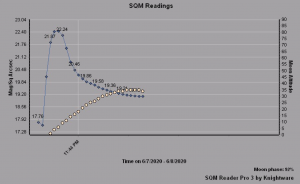
Credit: Putman Mountain Observatory
Hill Country Sky Quality Monitoring Network
The Putman Mountain Observatory has established a network of sky quality meters in various Hill Country locations and is currently working with the Hill Country Alliance to further expand the network throughout the region.
Credit: Hill Country Alliance
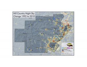
Hill Country Night Skies Mapping
1992 – 2010 Map Set
The Hill Country Night Skies map set is a set of 6 maps showing the night time light intensity of the Hill Country in 1992, 1995, 2000, and 2010. The final map shows the change in intensity from 1992 to 2010. The data was collected by the National Oceanic and Atmospheric Administration.
Click here to view or download the Hill Country Night Skies 1992 – 2010 map set.

Credit: Amy Jackson
Dark Sky Quality Analysis
Being able to both understand and explain the quality of our region’s night skies is critical to effective communication with both policy makers and the general public. In an effort to better inform Hill Country residents of our region’s sky quality, the Central Texas Dark Sky Quality Analysis was created in 2019 by Amy Jackson. This project was completed as part of an Austin Community College GIS program Capstone Project, in collaboration with the Hill Country Alliance.
Click here to view or download the 2019 Central Texas Dark Sky Quality poster with map and data table. To explore the same analysis for the entire State of Texas, click here.
Additional Resources Beyond the Hill Country
Globe at Night Interactive Map
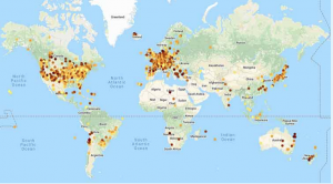
Credit: Globe at Night
Globe at Night Interactive Map
Globe at Night is an international citizen science campaign that has been collecting data about the night sky since 2006, in order to raise public awareness about the global spread of light pollution. Over the years, data has been collected from more than 200,000 observations across 180 countries.
Click here to explore data and maps from Globe at Night.
To participate in this project and submit your data click here.
World Map of Artificial Sky Brightness
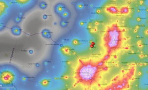
Credit: The New World Atlas of Artificial Night Sky Brightness
World Map of Artificial Sky Brightness
This easily navigable, interactive light pollution map displays overlays of night time lights on our planet. It shows night time lights as well as the World Map of Artificial Sky Brightness map layer. This map was created by an international team of scientists using high resolution satellite data – click here to learn more.
Recent Night Sky News
Hill Country Dark Sky Conference shines light on night sky preservation
Annual Event Returns to the Region, Uniting Leaders and Advocates to Combat Light Pollution Blanco, Texas – “Our skies are not just a backdrop; they are part of our heritage, our science, and our spirit,” said Mayor Candy Cargill of Blanco, who welcomed participants...
The Hill Country is celebrating the stars and night sky throughout October
The fifth annual Hill Country Night Sky Month is here. The October celebration affords people the chance to enjoy one of the region’s most beloved features, the star-filled sky. The Hill Country Alliance (HCA) and dozens of partners make this a community-wide event....
Shield Ranch Barton Creek named the first Urban Night Sky Place in Texas
DarkSky International officially certified Shield Ranch Barton Creek as an Urban Night Sky Place (UNSP). Shield Ranch joins three neighboring designated International Dark Sky Places; Dripping Springs and Bee Cave, Texas – both International Dark Sky Communities – and...
Shield Ranch Barton Creek named first Urban Night Sky Place in Texas
“Shield Ranch is Texas’s 20th International Dark Sky Place certified in the International Dark Sky Places program. In addition to three Developments of Distinction, there are now 23 internationally recognized sites in the state that have gone above and beyond in the...